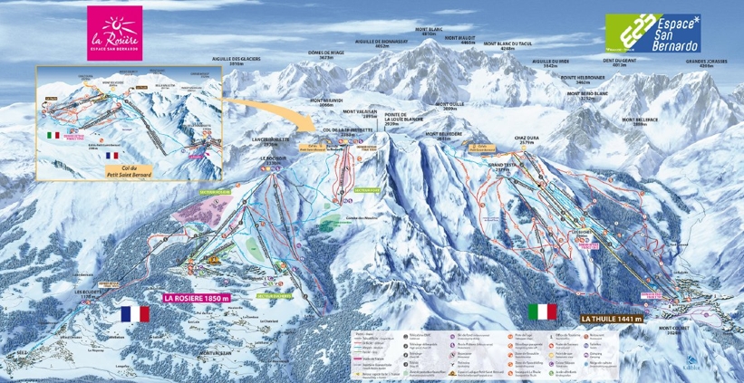
La Rosière piste map Skiing & snowboarding in La Rosière and around the Espace San Bernardo
One look at the La Rosière piste map shows the extent of the ski area. When you add in La Thuile on the Italian side, you'll definitely need your trail map to navigate the 150km of connected pistes!
The La Rosière - La Thuile sector is fun for all levels of skier although beginners and intermediates are certainly in for a treat with high altitude skiing, 1100m vertical decents and some long cruising blues and reds.
One of the best trails is from the top of the Fourclaz Express lift. From there its 11kms down to La Thuile passing through sunny bowls and tree-lined pistes on the lower slopes - perfect for intermediates.
Ski Touring
LA Rosiere's ski area also boasts 3 fantastic ski touring trails
- The Stoat’s Trail - a 754m uphill climb to Les Ecudets (Séez) and back to La Rosière
- Serge’s Trail - this takes you from Les Eucherts to Roc Noir and involves 488m of uphill using skins
- The Roc Trail - this starts from the village and using skins, takes you up 483m to Roc Noir
| Piste map information | |
|---|---|
| Black | 13 |
| Red | 31 |
| Blue | 25 |
| Beginner areas | 8 |
| Drags | 14 |
| Chair | 18 |
| Gondola | 1 |
| Cable car | 0 |
| Funicular | 0 |
| Railways | 0 |
| Slope direction | S |
| Mountain restaurants | 25 |
La Rosière trail & ski area map

