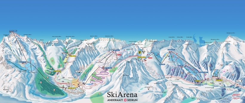
Andermatt piste map Skiing & snowboarding ski area and trail map of Andermatt-Sedrun arena
The Andermatt piste map shows the 4 main ski areas of Gemsstock, Sedrun, Realp and Nätschen. Currently, the sectors are not lift-linked so getting from one area to another is via the free ski bus or train which is included in the lift pass. A project is currently underway to link Andermatt with Sedrun that us due for completion in 2018.
Oberalp-Sedrun
- 7 ski lifts
- Varied and wide slopes for all levels
- very popular with snowboarders
- Snowpark Valtgeva Sedrun
- Big kids park
- kids restaurant and snowtubing
Andermatt-Realp
The small village of Realp at the end of the Ursern Valley is the last settlement before the Furka Pass.
- 1 ski lift
- Kids park
- Beginners area
| Piste map information | |
|---|---|
| Black | 10 |
| Red | 23 |
| Blue | 9 |
| Beginner areas | 2 |
| Drags | 12 |
| Chair | 8 |
| Gondola | 0 |
| Cable car | 2 |
| Funicular | 1 |
| Railways | 0 |
| Slope direction | N,S,E,W |
| Mountain restaurants | 8 |
Andermatt-Gemsstock
The majestic, north-facing Gemsstock mountain which is the highest in Andermatt delivers skiers to its 2,963m peak and is where the freeriders and expert skiers head to.
- 3 ski lifts
- High alpine pistes
- Fantastic off-piste backcountry terrain
Andermatt-Nätschen
- 4 ski lifts
- Sunny slopes and ideal for families
- Sledging
Andermatt trail & ski area map

