
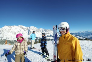
Maria Alm piste map Skiing & snowboarding in Maria Alm and around Hochkönig
The local skiing area is great for beginners, early intermediates and mixed ability groups with plenty of wide crusing green and blue runs flanked by deep forests.
Intermediate skiers will love the more challenging terrain along the 32km Kings Tour taking in the ski resorts of Muehlbach and Dienten or around the Ski Circus of Saalbach and Hinterglemm which has lots of challenging reds, blacks and off-piste.
| Piste map information | |
|---|---|
| Black | 4 |
| Red | 15 |
| Blue | 10 |
| Beginner areas | 5 |
| Drags | 7 |
| Chair | 4 |
| Gondola | 3 |
| Cable car | 0 |
| Funicular | 0 |
| Railways | 0 |
| Slope direction | N, S, E, W |
| Mountain restaurants | |
The other secret about skiing in Maria Alm is that the resort is part of the Amadé area that opens up 860km of pistes across 25 resorts - you will definitely need your Maria Alm piste map to navigate around! Note that not all the pistes are lift connected and short rides on the shuttle buses will be required to get you to and from some resorts.
| Salzburger Sportwelt | Schladming-dachstein | Gastein Valley | Hochkönig Massif | Großarltal Valley |
|---|---|---|---|---|
| Flachau | Planai-Hochwurzen | Dorfgastein | Dienten | Großarl |
| Wagrain | Hauser-Kaibling | Bad Gastein | Mühlbach | Hüttschlag |
| St.Johann-Alpendorf | Reiteralm | Hofgastein | Maria Alm | |
| Radstadt | Forstau-Fageralm | Sportgastein | ||
| Altenmarkt | Dachstein-Glacier | |||
| Kleinarl | Ramsau | |||
| Eben | ||||
| Filzmoos |
Maria Alm trail & Hochkönig ski area map

